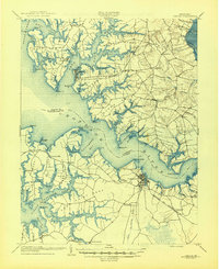
1904 Map of Oxford
USGS Topo · Published 1945About this map
The Choptank River and its intricate network of necks and creeks dominate this coastal survey of the Maryland Eastern Shore. At the turn of the twentieth century, the regional economy relied heavily on both the water and the rail, evidenced by the numerous wharves like Corners Wharf and Travers Whf. alongside the expansion of the Cambridge and Seaford R. R. and the B. C. & A. R. R. The settlement of Cambridge stands as a primary hub, while smaller towns like Oxford and Trappe anchor the agricultural and maritime peninsulas of Bailey s Neck and Island Neck. Cultural landmarks such as Trappe Ldg. and Christs Rock provide specific points of interest for genealogists tracing local families. The map also delineates the complex shoreline of Dickinson Bay and Lecompte Bay, reflecting the geography of the Chesapeake tidewater before modern coastal development.
Find a feature on this map
97 named features on this map. Tap any name to fly to it.
Don’t see what you’re looking for? This feature index may not catch every label — zoom into the map to look around manually.
Map Details
Editions of this 1904 Oxford Map
3 editions found

Other maps of this area

1892 · Drum Point
USGS Topo · 1:62,500

1892 · Annapolis
USGS Topo · 1:62,500

1893 · Sharps Island
USGS Topo · 1:62,500

1898 · Choptank
USGS Topo · 1:125,000

1898 · St. Marys
USGS Topo · 1:125,000

1901 · Drum Point
USGS Topo · 1:62,500

1903 · Nanticoke
USGS Topo · 1:62,500

1904 · St. Michaels
USGS Topo · 1:62,500

1904 · Annapolis
USGS Topo · 1:62,500

1904 · Sharps Island
USGS Topo · 1:62,500