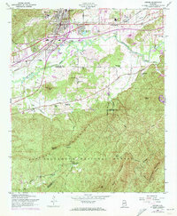
1956 Map of Oxford
USGS Topo · Published 1973About this map
Hobson City and Oxford stand at the edge of the Talladega National Forest, where the industrial and municipal growth of eastern Alabama meets the high ridges of the Appalachian foothills. This landscape is defined by the proximity of community centers like the Rising Star Ch and County Training Sch to the natural corridors of Choecolocco Creek. Transportation hubs including Lee Brothers Airfield and the Anniston Municipal Airport reflect the era's mid-century aviation and transit expansion. Southward, the map transitions into heavily forested terrain, where the Lookout Tower Kentuck Ranger Sta overlooks peaks like Kentuck Mountain and Horseblock Mountain. This map records a specific social geography, documenting numerous local congregations such as Sweet Rock Ch and Bethlehem Ch that served as the anchors for rural settlements like Boiling Spring and McAding.
Find a feature on this map
46 named features on this map. Tap any name to fly to it.
Don’t see what you’re looking for? This feature index may not catch every label — zoom into the map to look around manually.
Map Details
Editions of this 1956 Oxford Map
3 editions found

Other maps of this area

1891 · Ashland
USGS Topo · 1:125,000

1900 · Anniston
USGS Topo · 1:125,000

1947 · Oxford
USGS Topo · 1:24,000

1947 · Anniston
USGS Topo · 1:24,000

1947 · Eulaton
USGS Topo · 1:24,000

1947 · Munford
USGS Topo · 1:24,000

1950 · Anniston
USGS Topo · 1:62,500

1953 · Atlanta
USGS Topo · 1:250,000

1954 · Choccolocco
USGS Topo · 1:24,000

1956 · Munford
USGS Topo · 1:24,000