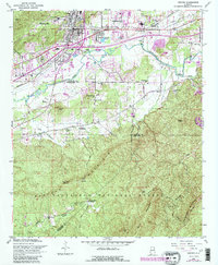
1956 Map of Oxford
USGS Topo · Published 1984About this map
Oxford and southern Anniston sit at the intersection of industry and nature in the mid-1950s, bounded by the peaks of Horseblock Mountain and Oak Mtn. The landscape reveals a complex network of community landmarks, including the County Training Sch and numerous country churches like Oak Ridge Ch and Pure Holiness Ch that anchored local life. To the south, the terrain transitions into the dense woods of the Talladega National Forest and Kentuck State Park, where the Kentuck Ranger Sta and Duck Nest Springs are situated away from the urban center.
Find a feature on this map
46 named features on this map. Tap any name to fly to it.
Don’t see what you’re looking for? This feature index may not catch every label — zoom into the map to look around manually.
Map Details
Editions of this 1956 Oxford Map
3 editions found

Other maps of this area

1891 · Ashland
USGS Topo · 1:125,000

1900 · Anniston
USGS Topo · 1:125,000

1947 · Oxford
USGS Topo · 1:24,000

1947 · Anniston
USGS Topo · 1:24,000

1947 · Eulaton
USGS Topo · 1:24,000

1947 · Munford
USGS Topo · 1:24,000

1950 · Anniston
USGS Topo · 1:62,500

1953 · Atlanta
USGS Topo · 1:250,000

1954 · Choccolocco
USGS Topo · 1:24,000

1956 · Munford
USGS Topo · 1:24,000