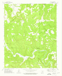
1973 Map of Oxley
USGS Topo · Published 1975About this map
Half Moon Mountain and the winding course of the Little Red River dominate this pocket of north-central Arkansas, where the borders of Searcy, Stone, and Van Buren Counties converge. The landscape is defined by deep hollows and high ridges, with small communities like Oxley and Elba providing focal points for local commerce and rural life. Traces of past industry are visible along the riverbanks, most notably the route of an Old Railroad that follows the water's edge through Mill Hollow, suggesting the era of timber or mineral extraction that once moved through these hills.
Find a feature on this map
42 named features on this map. Tap any name to fly to it.
Don’t see what you’re looking for? This feature index may not catch every label — zoom into the map to look around manually.
Map Details
Editions of this 1973 Oxley Map
2 editions found
Other maps of this area

1892 · Marshall
USGS Topo · 1:125,000

1892 · Mountain View
USGS Topo · 1:125,000

1894 · Mountain View
USGS Topo · 1:125,000

1894 · Marshall
USGS Topo · 1:125,000

1901 · Marshall
USGS Topo · 1:125,000

1956 · Russellville
USGS Topo · 1:250,000
1963 · Harriet
USGS Topo · 1:24,000

1963 · Leslie
USGS Topo · 1:24,000

1964 · Russellville
USGS Topo · 1:250,000
1965 · Botkinburg
USGS Topo · 1:24,000