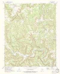
1973 Map of Oxley
USGS Topo · Published 1975About this map
The Middle Fork Little Red River carves a deep winding path through this corner of the Ozarks, where the tri-county borders of Searcy, Van Buren, and Stone counties converge. Small settlements like Oxley and Campbell are situated on higher ground above the river valley, connected by rural routes and a visible railroad grade. The landscape is defined by isolated peaks and ridges, including Lee Mountain, Styles Mountain, and Angora Mountain, often separated by deep-cut hollows such as Avery Hollow and Rattlesnake Hollow. Local history is anchored by rural landmarks like the Half Moon Ch and the Kuykendall Cem, alongside geological features such as Salts Cave Bluff and Lobe Patric Gap. The presence of a quarry near Oxley points to the local extraction of stone in an otherwise agricultural and timber-defined region.
Find a feature on this map
42 named features on this map. Tap any name to fly to it.
Don’t see what you’re looking for? This feature index may not catch every label — zoom into the map to look around manually.
Map Details
Editions of this 1973 Oxley Map
2 editions found
Other maps of this area

1892 · Marshall
USGS Topo · 1:125,000

1892 · Mountain View
USGS Topo · 1:125,000

1894 · Mountain View
USGS Topo · 1:125,000

1894 · Marshall
USGS Topo · 1:125,000

1901 · Marshall
USGS Topo · 1:125,000

1956 · Russellville
USGS Topo · 1:250,000
1963 · Harriet
USGS Topo · 1:24,000

1963 · Leslie
USGS Topo · 1:24,000

1964 · Russellville
USGS Topo · 1:250,000
1965 · Botkinburg
USGS Topo · 1:24,000