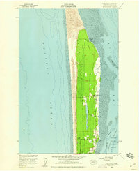
1957 Map of Oysterville
USGS Topo · Published 1959About this map
Oysterville sits on the sheltered eastern shore of the North Beach Peninsula, a landscape defined by the shifting barrier between the Pacific Ocean and the mudflats of Willapa Bay. This 1950s survey documents a coastal economy and community structure built around the bay's natural resources, from the oyster beds near Stackpole Harbor to the inland Cranberry Bog locations. The terrain is marked by a dramatic contrast between the high Sand Dunes on the ocean side and the low-lying interior marshes containing Skating Lake and Sherwood Forest. Small settlements like Ocean Park and Nahcotta are connected by the Peninsula Highway, while the Oysterville Cem and local landmarks like the Morehead Boys Camp provide specific points of interest for genealogists and local historians studying this stretch of the Washington coast.
Find a feature on this map
19 named features on this map. Tap any name to fly to it.
Don’t see what you’re looking for? This feature index may not catch every label — zoom into the map to look around manually.
Map Details
Editions of this 1957 Oysterville Map
4 editions found
Other maps of this area

1938 · Cape Disappointment
USGS Topo · 1:62,500

1938 · Cape Shoalwater
USGS Topo · 1:62,500

1938 · Fort Columbia
USGS Topo · 1:62,500

1938 · South Bend
USGS Topo · 1:62,500

1940 · South Bend
USGS Topo · 1:62,500

1943 · Fort Columbia
USGS Topo · 1:62,500

1943 · Copalis Beach
USGS Topo · 1:250,000

1949 · Ocean Park
USGS Topo · 1:24,000

1949 · Long Island
USGS Topo · 1:24,000

1951 · Copalis Beach
USGS Topo · 1:250,000