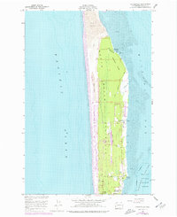
1957 Map of Oysterville
USGS Topo · Published 1977About this map
The North Beach Peninsula stretches between the churning Pacific Ocean and the tidal flats of Willapa Bay, defined by a narrow strip of coastal land that supported a unique maritime and agricultural economy. The historic settlement of Oysterville sits on the eastern shore, a focal point for the oyster industry that flourished along the Willapa Channel. The landscape is a complex mix of Sand Dunes to the west and dense Sherwood Forest to the east, punctuated by specialized land uses such as a Cranberry Bog and several community landmarks including a Cem and Skating Lake. Civil development is concentrated along the Peninsula Highway, while the southern reaches transition into the protected environments of the Willapa National Wildlife Refuge. Recreation and youth programs are evident through the presence of Willapa Camp and Morehead Boys Camp, reflecting the area's mid-century character.
Find a feature on this map
27 named features on this map. Tap any name to fly to it.
Don’t see what you’re looking for? This feature index may not catch every label — zoom into the map to look around manually.
Map Details
Editions of this 1957 Oysterville Map
4 editions found
Other maps of this area

1938 · Cape Disappointment
USGS Topo · 1:62,500

1938 · Cape Shoalwater
USGS Topo · 1:62,500

1938 · Fort Columbia
USGS Topo · 1:62,500

1938 · South Bend
USGS Topo · 1:62,500

1940 · South Bend
USGS Topo · 1:62,500

1943 · Fort Columbia
USGS Topo · 1:62,500

1943 · Copalis Beach
USGS Topo · 1:250,000

1949 · Ocean Park
USGS Topo · 1:24,000

1949 · Long Island
USGS Topo · 1:24,000

1951 · Copalis Beach
USGS Topo · 1:250,000