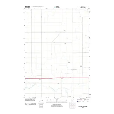
2010 Map of Oza Tanka Lakebed
USGS Topo · Published 2010About this map
The Oza Tanka Lakebed defines this portion of Faribault County, where a former lake basin has been repurposed into a vast agricultural grid. The landscape is heavily modified by hydraulic engineering, evidenced by the intricate network of channels including County Ditch Number Five, County Ditch Number Twentyfive, and Judicial Ditch Number Six. These waterways feed into the East Branch Blue Earth River, which meanders across the southern portion of the map.
Find a feature on this map
37 named features on this map. Tap any name to fly to it.
Don’t see what you’re looking for? This feature index may not catch every label — zoom into the map to look around manually.
Map Details
Editions of this 2010 Oza Tanka Lakebed Map
This is the sole edition of this map. No revisions or reprints were ever made.
Other maps of this area

1954 · Fairmont
USGS Topo · 1:250,000

1954 · Mason City
USGS Topo · 1:250,000

1955 · Bricelyn
USGS Topo · 1:62,500

1957 · Mason City
USGS Topo · 1:250,000

1958 · Mason City
USGS Topo · 1:250,000

1958 · Fairmont
USGS Topo · 1:250,000

1967 · Minnesota Lake
USGS Topo · 1:24,000

1967 · Elmore
USGS Topo · 1:24,000
1967 · Easton
USGS Topo · 1:24,000
1967 · Delavan
USGS Topo · 1:24,000