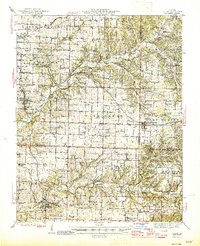
1945 Map of Ozark
USGS Topo · Published 1945About this map
James River and Finley Creek drain this mid-1940s landscape, where the karst topography of the Missouri hills reveals itself through numerous subterranean features like Garrison Cave, Smallen Cave, and Wood Cave. The St Louis San Francisco Railroad provides a primary transit corridor, connecting the rural communities of Rogersville, Galloway, and Ozark. At the northern edge, the transition toward the Springfield area is evident with the Springfield Airport and the Airport Radio Sta located near Langston.
Find a feature on this map
108 named features on this map. Tap any name to fly to it.
Don’t see what you’re looking for? This feature index may not catch every label — zoom into the map to look around manually.
Map Details
Editions of this 1945 Ozark Map
2 editions found

Other maps of this area

1884 · Springfield
USGS Topo · 1:125,000

1886 · Springfield
USGS Topo · 1:125,000

1907 · Forsyth
USGS Topo · 1:125,000

1935 · Springfield
USGS Topo · 1:24,000

1937 · Galloway
USGS Topo · 1:24,000

1937 · Bradleyville
USGS Topo · 1:48,000

1937 · Ozark
USGS Topo · 1:48,000

1939 · Fordland
USGS Topo · 1:62,500

1942 · Fordland
USGS Topo · 1:62,500

1943 · Ozark
USGS Topo · 1:62,500