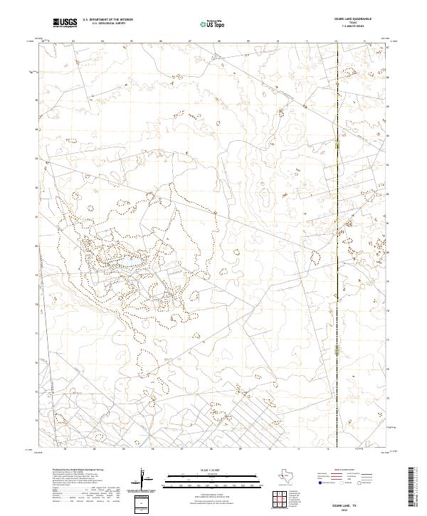
2022 Map of Ozark Lake
USGS Topo · Published 2022About this map
Ozark Lake serves as a central landmark in this West Texas landscape, where the flat, arid terrain is marked by a complex network of oil field roads and section lines. Surveyed by the U.S. Geological Survey, the area straddles the county line between Ward County and Crane County. The mapping reveals a sparse environment dominated by infrastructure rather than settlements, with numerous unmarked roads and pads characteristic of Permian Basin energy development. Primary access to the region is provided by Ranch Rd 1233 in the northeast and S Stockton Ave along the western edge. Notable local routes such as Co Rd 2085, Co Rd 241, and Co Rd 245 crisscross the plains, providing a detailed record of the industrial and rural transportation grid used by landowners and mineral operators.
Find a feature on this map
10 named features on this map. Tap any name to fly to it.
Don’t see what you’re looking for? This feature index may not catch every label — zoom into the map to look around manually.
Map Details
Editions of this 2022 Ozark Lake Map
This is the sole edition of this map. No revisions or reprints were ever made.
Other maps of this area

1954 · Pecos
USGS Topo · 1:250,000

1957 · Pecos
USGS Topo · 1:250,000

1964 · Penwell SW
USGS Topo · 1:24,000

1968 · Monahans SE
USGS Topo · 1:24,000

1969 · Ozark Lake
USGS Topo · 1:24,000

1969 · Grandfalls
USGS Topo · 1:24,000

1969 · Monahans
USGS Topo · 1:24,000

1969 · 7 L Ranch
USGS Topo · 1:24,000
1974 · Imperial NW
USGS Topo · 1:24,000
1974 · Imperial
USGS Topo · 1:24,000