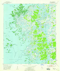
1954 Map of Ozello
USGS Topo · Published 1959About this map
The coastal island community of Ozello anchors this mid-century survey of the Citrus County shoreline, where a maze of sawgrass, mangroves, and tidal creeks meets the Gulf of Mexico. Connected by a single winding road labeled 494, the settlement is surrounded by a complex hydrography of tidal passages like the Narrows and Grey Mare Pass. To the south, the Homosassa River flows past Homosassa and Shell Island into the expansive Homosassa Bay. The lower portion of the sheet is largely defined by the protected acreage of the Chassahowitzka National Wildlife Refuge, preserving a wilderness of named waterways such as Mason Creek and Petty Creek. Navigational markers, including numerous daybeacons and a Platform near Ship Rock, indicate the area's importance for local maritime traffic through the shallow bays and the St Martins Keys archipelago.
Find a feature on this map
70 named features on this map. Tap any name to fly to it.
Don’t see what you’re looking for? This feature index may not catch every label — zoom into the map to look around manually.
Map Details
Editions of this 1954 Ozello Map
5 editions found
Other maps of this area

1954 · Homosassa
USGS Topo · 1:24,000

1954 · Chassahowitzka Bay
USGS Topo · 1:24,000

1954 · Crystal River
USGS Topo · 1:24,000

1954 · Chassahowitzka
USGS Topo · 1:24,000

1954 · Red Level
USGS Topo · 1:24,000

1954 · Ozello
USGS Topo · 1:24,000

1955 · Plant City
USGS Topo · 1:250,000

1958 · Plant City
USGS Topo · 1:250,000

1959 · Plant City
USGS Topo · 1:250,000

1964 · Plant City
USGS Topo · 1:250,000