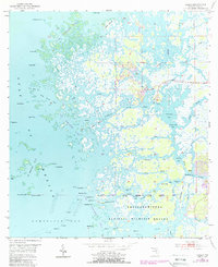
1954 Map of Ozello
USGS Topo · Published 1988About this map
Ozello sits as a primary outpost on this coastal survey, linked to the mainland by road 494. The landscape is a complex labyrinth of mangrove islands and tidal channels where the Salt River and St Martins River meet the Gulf of Mexico. Much of the area is dedicated to conservation, spanning the St Martins Marsh State Aquatic Preserve and the Chassahowitzka National Wildlife Refuge.
Find a feature on this map
71 named features on this map. Tap any name to fly to it.
Don’t see what you’re looking for? This feature index may not catch every label — zoom into the map to look around manually.
Map Details
Editions of this 1954 Ozello Map
5 editions found
Other maps of this area

1954 · Homosassa
USGS Topo · 1:24,000

1954 · Chassahowitzka Bay
USGS Topo · 1:24,000

1954 · Crystal River
USGS Topo · 1:24,000

1954 · Chassahowitzka
USGS Topo · 1:24,000

1954 · Red Level
USGS Topo · 1:24,000

1954 · Ozello
USGS Topo · 1:24,000

1955 · Plant City
USGS Topo · 1:250,000

1958 · Plant City
USGS Topo · 1:250,000

1959 · Plant City
USGS Topo · 1:250,000

1964 · Plant City
USGS Topo · 1:250,000