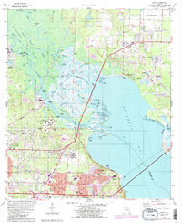
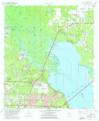
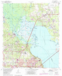
1978 Map of Pace
USGS Topo · Published 1987About this map
The Escambia River delta dominates this 1970s landscape, weaving a complex network of waterways including the Bannahassee River, Little River, and Simpson River around Noriegas Island. This period captures the expanding suburban footprint north of Pensacola, where residential growth in Pace and Ferry Pass meets the industrial activities marked by numerous Industrial Waste Ponds and a large Powerplant along the riverbanks. The educational and social infrastructure of the era is well-defined, featuring the University of West Florida campus and local landmarks like the Whitmire Cem and Escambia Chapel. The map reveals a transitional economy where older maritime features like the Ferry Cutoff and Saultsman Bayou coexist with modern utility corridors and the CSX railroad line, illustrating the region's evolution from a river-dependent territory to a modern Florida hub.
Find a feature on this map
93 named features on this map. Tap any name to fly to it.
Don’t see what you’re looking for? This feature index may not catch every label — zoom into the map to look around manually.
Map Details
Editions of this 1978 Pace Map
3 editions found
Other maps of this area

1920 · Milton
USGS Topo · 1:62,500

1921 · Pensacola
USGS Topo · 1:62,500

1921 · Fort Barrancas
USGS Topo · 1:62,500

1921 · Muscogee
USGS Topo · 1:62,500

1941 · Fort Barrancas
USGS Topo · 1:62,500

1941 · Muscogee
USGS Topo · 1:62,500

1941 · Pensacola
USGS Topo · 1:62,500

1941 · Milton
USGS Topo · 1:62,500

1942 · Pensacola
USGS Topo · 1:62,500

1943 · Muscogee
USGS Topo · 1:62,500