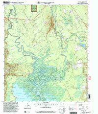
2003 Map of Pace Hill
USGS Topo · Published 2004About this map
Angelina River meanders through a dense network of sloughs and bottomlands along the Tyler and Jasper County border. This 2003 revision, based on earlier surveys, highlights the intricate hydrology of the area, featuring named water bodies such as Barrow Lake, Huddley Lakes, and Old River Lakes. Significant historical markers emphasize the region's heritage, notably the Bevilport Townsite Historical Monument and the Dr Steven H Everitt Historical Monument near the riverbanks. Small communities and landmarks are scattered across the terrain, including Homer, Fox Landing, and the Dixie Community Ch. The landscape is characterized by prominent ridges and islands like Pace Hill, Frank Camp Ridge, and Big Pine Island, which rise above the surrounding Johnson Flats. The map also details local infrastructure, from the Jasper State Fish Hatchery to the various pipelines and communication towers that serve this part of the Angelina National Forest.
Find a feature on this map
67 named features on this map. Tap any name to fly to it.
Don’t see what you’re looking for? This feature index may not catch every label — zoom into the map to look around manually.
Map Details
Editions of this 2003 Pace Hill Map
This is the sole edition of this map. No revisions or reprints were ever made.
Other maps of this area

1931 · Zavalla
USGS Topo · 1:62,500

1953 · Palestine
USGS Topo · 1:250,000

1954 · Beaumont
USGS Topo · 1:250,000

1955 · Woodville
USGS Topo · 1:62,500

1955 · Curtis
USGS Topo · 1:62,500

1957 · Beaumont
USGS Topo · 1:250,000

1957 · Palestine
USGS Topo · 1:250,000

1958 · Zavalla
USGS Topo · 1:62,500

1958 · Mc Gee Bend
USGS Topo · 1:62,500

1984 · Beaumont
USGS Topo · 1:250,000