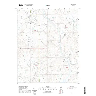
2021 Map of Paden
USGS Topo · Published 2021About this map
The Tennessee Valley Divide cuts through this portion of northeast Mississippi, separating the drainage systems of Mackeys Cr and its various tributaries like Hurricane Br and Burgess Cr. The landscape is a network of ridges and bottoms, most notably Clausel Hill Bottom and the prominent Barnett Knob. Small communities like Cairo, Paden, and Burton serve as local anchors, connected by a dense grid of county roads and historic corridors including the Natchez Trce. Genealogy researchers will find numerous family and community burial grounds, such as Callicot Family Cem, Forked Oak Cem, and Stricklen Cem, which are scattered throughout the hills. The presence of Burton Lake and numerous named branches like Dead Man Br and Cripple Deer Cr reflects the well-watered topography typical of the Tishomingo and Prentiss county line region.
Find a feature on this map
103 named features on this map. Tap any name to fly to it.
Don’t see what you’re looking for? This feature index may not catch every label — zoom into the map to look around manually.
Map Details
Editions of this 2021 Paden Map
This is the sole edition of this map. No revisions or reprints were ever made.
Other maps of this area

1911 · Iuka
USGS Topo · 1:48,000

1914 · Iuka
USGS Topo · 1:62,500

1935 · Holcut
USGS Topo · 1:24,000

1935 · Iuka
USGS Topo · 1:24,000

1935 · Leedy
USGS Topo · 1:24,000

1935 · Glens
USGS Topo · 1:24,000

1936 · Belmont
USGS Topo · 1:24,000

1936 · Tishomingo
USGS Topo · 1:24,000

1950 · Paden
USGS Topo · 1:24,000
1950 · Burnsville
USGS Topo · 1:24,000