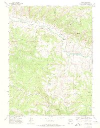
1971 Map of Pagoda
USGS Topo · Published 1974About this map
Williams Fork winds through the northwestern corner of this landscape, its waters diverted by the Peck Ditch and Highland Ditch to support the high-altitude ranching and agriculture of the region. The settlement of Pagoda sits near the confluence of the river and Daton Gulch, serving as a focal point for activity in this part of Northwest Colorado. To the south, the topography rises sharply toward Round Mountain and the boundaries of the Routt National Forest, where resource extraction is evident at the Cedar Creek Mine and several scattered gas wells. The presence of Oklahoma Flat highlights the occasional level expanses found between the numerous gulches, such as Berry Gulch and Searcy Gulch, that drain the surrounding highlands. This 1971 survey illustrates a transition from the riparian valleys to the higher timberlands, marked by a network of Trails and Jeep Trails used for land management and recreation.
Find a feature on this map
37 named features on this map. Tap any name to fly to it.
Don’t see what you’re looking for? This feature index may not catch every label — zoom into the map to look around manually.
Map Details
Editions of this 1971 Pagoda Map
4 editions found
Other maps of this area

1910 · Danforth Hills
USGS Topo · 1:125,000

1915 · Monument Butte
USGS Topo · 1:62,500

1916 · Daton Peak
USGS Topo · 1:62,500

1920 · Daton Peak
USGS Topo · 1:62,500

1954 · Craig
USGS Topo · 1:250,000

1957 · Craig
USGS Topo · 1:250,000

1958 · Craig
USGS Topo · 1:250,000

1960 · Craig
USGS Topo · 1:250,000

1962 · Craig
USGS Topo · 1:250,000

1964 · Craig
USGS Topo · 1:250,000