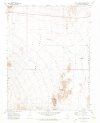
1970 Map of Pahroc Summit Pass
USGS Topo · Published 1973About this map
Pahroc Summit Pass serves as the primary transit point through the high terrain of Lincoln County on this 1970s topographic survey. The landscape is defined by the massive north-south elevations of the Pahroc Range and South Pahroc Range, which separate the expansive Pahroc Valley from the adjacent Delamar Valley to the east. Human infrastructure in this arid environment is sparse and largely focused on water management and resource exploration. Small reservoirs like White Sage Res, Knoll Pond Res, and MacKay Res are scattered across the flats, while a single Drill Hole and a Water Tank indicate localized mining or ranching activity. Route 93 provides the only major thoroughfare, cutting across the northern reaches of the quadrangle.
Find a feature on this map
14 named features on this map. Tap any name to fly to it.
Don’t see what you’re looking for? This feature index may not catch every label — zoom into the map to look around manually.
Map Details
Editions of this 1970 Pahroc Summit Pass Map
2 editions found
Other maps of this area

1885 · Pioche
USGS Topo · 1:250,000

1886 · Pioche
USGS Topo · 1:250,000

1945 · Alamo
USGS Topo · 1:125,000

1954 · Caliente
USGS Topo · 1:250,000

1959 · Caliente
USGS Topo · 1:250,000

1969 · Delamar
USGS Topo · 1:24,000

1969 · Alamo NE
USGS Topo · 1:24,000

1969 · Delamar NW
USGS Topo · 1:24,000

1970 · Hiko NE
USGS Topo · 1:24,000

1970 · Hiko SE
USGS Topo · 1:24,000