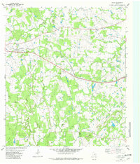
1982 Map of Paige
USGS Topo · Published 1982About this map
The Southern Pacific railroad line forms the industrial backbone of this Central Texas landscape, cutting through the settlement of Paige near the Bastrop and Lee county line. The map captures a rural community defined by its creeks and family-named landmarks, where small-scale farming and ranching are indicated by the scattering of schools and churches across the rolling terrain. The presence of the Independent Sch and St Johns Ch near the rail line suggests the historical concentration of community life along the transport corridor, while more secluded sites like St Delight Ch and the associated St Delight Cem are tucked away along the banks of Cedar Creek. To the east, the village of Manheim serves as a secondary cluster of activity, anchored by Ebenezer Ch and the winding course of Schilling Branch. This 1980s-era documentation preserves a landscape of naming traditions, from the colorful Dead Mans Hole Creek to the Grassyville Cem.
Find a feature on this map
32 named features on this map. Tap any name to fly to it.
Don’t see what you’re looking for? This feature index may not catch every label — zoom into the map to look around manually.
Map Details
Editions of this 1982 Paige Map
This is the sole edition of this map. No revisions or reprints were ever made.
Other maps of this area

1885 · Bastrop
USGS Topo · 1:125,000

1893 · Bastrop
USGS Topo · 1:125,000

1904 · Bastrop
USGS Topo · 1:125,000

1919 · Giddings
USGS Topo · 1:62,500

1919 · Dime Box
USGS Topo · 1:62,500

1948 · Smithville
USGS Topo · 1:62,500

1948 · Lexington
USGS Topo · 1:62,500

1950 · Lexington
USGS Topo · 1:62,500

1950 · Smithville
USGS Topo · 1:62,500

1954 · Austin
USGS Topo · 1:250,000