
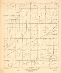
1927 Map of Paige
USGS Topo · Published 1927About this map
Agricultural development in the San Joaquin Valley is clearly visible in this 1920s survey, dominated by a dense grid of rural roads and irrigation works. The tiny settlement of Paige sits at the junction of the Atchison Topeka and Santa Fe railroad, serving as a transit point for the surrounding farmsteads. A series of country schools, including Buena Vista School, Walnut Grove School, Linder School, and Laurel School, are spaced across the landscape to serve the local ranching families. The complex hydrology of the area is represented by natural waterways like Packwood Creek and Deep Creek alongside man-made improvements such as the Tulare Canal and Rockyford Ditch. These features illustrate the early 20th-century transition from dry creek beds to a managed irrigation system that enabled intensive farming in Tulare County.
Find a feature on this map
19 named features on this map. Tap any name to fly to it.
Don’t see what you’re looking for? This feature index may not catch every label — zoom into the map to look around manually.
Map Details
Editions of this 1927 Paige Map
2 editions found
Other maps of this area

1925 · Tulare
USGS Topo · 1:31,680

1925 · Tipton
USGS Topo · 1:31,680

1926 · Goshen
USGS Topo · 1:31,680

1927 · Remnoy
USGS Topo · 1:31,680

1927 · Lake View School
USGS Topo · 1:31,680

1927 · Visalia
USGS Topo · 1:31,680

1927 · Tulare
USGS Topo · 1:31,680

1928 · Tipton
USGS Topo · 1:31,680

1928 · Waukena
USGS Topo · 1:31,680

1928 · Corcoran
USGS Topo · 1:31,680