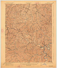
1917 Map of Paintsville
USGS Topo · Published 1927About this map
Paintsville serves as the focal point of this Johnson County landscape, situated at the confluence of the Levisa Fork and Paint Creek. The mapping reveals a densely settled rural economy defined by a network of numbered schools, such as School No 1 and School No 12, scattered along winding valley floors. The Chesapeake and Ohio railroad tracks follow the river's path, connecting the county seat with industrial points like West Van Lear and the Thelma P O Buffalo Sta.
Find a feature on this map
122 named features on this map. Tap any name to fly to it.
Don’t see what you’re looking for? This feature index may not catch every label — zoom into the map to look around manually.
Map Details
Editions of this 1917 Paintsville Map

Other maps of this area

1886 · Prestonsburg
USGS Topo · 1:125,000

1889 · Salyersville
USGS Topo · 1:125,000

1891 · Salyersville
USGS Topo · 1:125,000

1892 · Prestonsburg
USGS Topo · 1:125,000

1899 · Salyersville
USGS Topo · 1:125,000

1903 · Kenova
USGS Topo · 1:125,000

1904 · Kenova
USGS Topo · 1:125,000

1911 · Louisa
USGS Topo · 1:48,000

1913 · Louisa
USGS Topo · 1:62,500

1914 · Laynesville
USGS Topo · 1:48,000