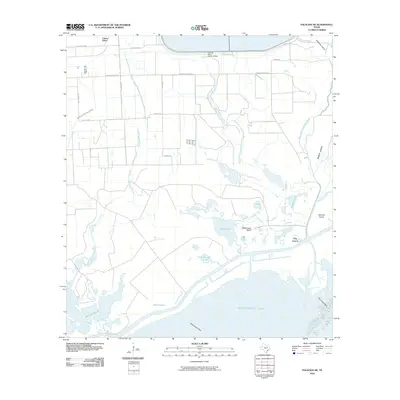
2010 Map of Palacios NE
USGS Topo · Published 2010About this map
Citrus Grove anchors the northwest corner of this coastal landscape, where the flat Texas prairie gives way to the intricate wetlands of the Gulf Coast. The terrain is defined by an extensive network of waterways, including East Branch Mad Island Slough and Robbins Slough, which drain toward the vast expanse of Matagorda Bay. The interplay of salt and fresh water is evident in the cluster of coastal features such as Mad Island Lake, Crab Lake, and Freshwater Lake, alongside named landforms like Rattlesnake Island and Wild Cow Island. Modern infrastructure is represented by the Cooling Water Reservoir Dam in the north, while the southern reach shows the submerged hazards of Shell Island Reef and Dog Island Reef. This 2010 survey reflects the coastal geography of Matagorda County, illustrating how rural roads like Corporon Rd and Savage Rd navigate the low-lying sloughs and island chains.
Find a feature on this map
32 named features on this map. Tap any name to fly to it.
Don’t see what you’re looking for? This feature index may not catch every label — zoom into the map to look around manually.
Map Details
Editions of this 2010 Palacios NE Map
This is the sole edition of this map. No revisions or reprints were ever made.
Other maps of this area

1951 · Bay City
USGS Topo · 1:250,000

1952 · Palacios SE
USGS Topo · 1:24,000

1952 · Palacios Point
USGS Topo · 1:24,000

1952 · Matagorda
USGS Topo · 1:24,000

1952 · Blessing SE
USGS Topo · 1:24,000

1952 · Palacios
USGS Topo · 1:24,000
1952 · Matagorda SW
USGS Topo · 1:24,000

1952 · Blessing
USGS Topo · 1:24,000

1952 · Palacios NE
USGS Topo · 1:24,000

1952 · Wadsworth
USGS Topo · 1:24,000