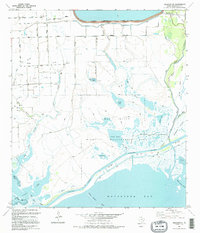
1995 Map of Palacios NE
USGS Topo · Published 1995About this map
Matagorda Bay defines the southern reach of this coastal landscape, where the Intracoastal Waterway cuts through a complex of salt marshes and tidal flats. The interior is a specialized ecosystem dominated by the Mad Island Wildlife Management Area, featuring a labyrinth of water bodies including Crab Lake, Freshwater Lake, and Mad Island Lake. Evidence of human infrastructure is found further north at the settlement of Citrus Grove, where an Old RR Grade and Gillett Road serve as remnants of earlier transportation patterns. The map documents an industrial presence on the land through numerous gas wells scattered across the prairie, while the coastal edge is defined by prominent features like Shell Island Reef and Dog Island Reef. Extensive levee systems and sloughs, such as Little Robbins Slough, illustrate the region's managed hydrology and its proximity to the Colorado River delta.
Find a feature on this map
35 named features on this map. Tap any name to fly to it.
Don’t see what you’re looking for? This feature index may not catch every label — zoom into the map to look around manually.
Map Details
Editions of this 1995 Palacios NE Map
This is the sole edition of this map. No revisions or reprints were ever made.
Other maps of this area

1951 · Bay City
USGS Topo · 1:250,000

1952 · Palacios SE
USGS Topo · 1:24,000

1952 · Palacios Point
USGS Topo · 1:24,000

1952 · Matagorda
USGS Topo · 1:24,000

1952 · Blessing SE
USGS Topo · 1:24,000

1952 · Palacios
USGS Topo · 1:24,000
1952 · Matagorda SW
USGS Topo · 1:24,000

1952 · Blessing
USGS Topo · 1:24,000

1952 · Palacios NE
USGS Topo · 1:24,000

1952 · Wadsworth
USGS Topo · 1:24,000