
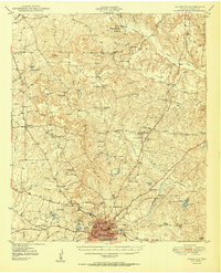
1950 Map of Palestine
USGS Topo · Published 1950About this map
Palestine anchors the southern portion of this mid-century survey, revealing a landscape defined by its numerous small-scale farming communities and the convergence of the Missouri and Pacific rail lines. To the north, the terrain transitions into a dense network of country schools and churches like Cuney Academy, Jerusalem Sch, and Watkins Chapel, many of which served dispersed rural populations before school consolidation. The geography is notably wet, marked by extensive wetlands such as Evergreen Marsh and Beaver Marsh along Beaver Creek. The presence of several city-fed water bodies, including City Lake and Spring Park Lake, underscores the infrastructure of the county seat as it expanded in the postwar years. Genealogists will find a high concentration of family-named landmarks and burial grounds, such as Swanson Cem and Dobbs Cem, providing clear evidence of the area's deep-rooted agrarian settlement patterns.
Find a feature on this map
65 named features on this map. Tap any name to fly to it.
Don’t see what you’re looking for? This feature index may not catch every label — zoom into the map to look around manually.
Map Details
Editions of this 1950 Palestine Map
2 editions found
Other maps of this area

1946 · Bullard
USGS Topo · 1:62,500

1948 · Bullard
USGS Topo · 1:62,500

1949 · Palestine
USGS Topo · 1:62,500

1949 · Frankston
USGS Topo · 1:62,500

1949 · Athens
USGS Topo · 1:62,500

1949 · Tennessee Colony
USGS Topo · 1:62,500

1950 · Athens
USGS Topo · 1:62,500

1950 · Frankston
USGS Topo · 1:62,500

1950 · Tennessee Colony
USGS Topo · 1:62,500

1951 · Elkhart
USGS Topo · 1:62,500