
1970 Map of Palisade
USGS Topo · Published 1972About this map
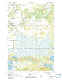
The Mississippi River winds in deep oxbow loops across this northern Minnesota landscape, where the village of Palisade serves as the primary hub for the surrounding townships of Logan, Workman, Fleming, and Jevne. In the early 1970s, the Soo Line railroad cuts a diagonal path southeast from the village, crossing a low-lying region dominated by a complex network of glacial lakes. To the south, a dense cluster of water bodies including Wilkins Lake, Jenkins Lake, and Long Lake indicates a region heavily utilized for recreation and local utility, evidenced by the public access points and a Townhall near the shore of Wilkins Lake. The survey reflects a period when the river-and-rail geography still dictated the local settlement pattern, with 232 providing one of the few improved road connections through the marshy terrain of central Aitkin County.
Find a feature on this map
18 named features on this map. Tap any name to fly to it.
Don’t see what you’re looking for? This feature index may not catch every label — zoom into the map to look around manually.
Map Details
Editions of this 1970 Palisade Map
2 editions found
Other maps of this area

1914 · Aitkin
USGS Topo · 1:62,500

1915 · Aitkin
USGS Topo · 1:62,500

1953 · Duluth
USGS Topo · 1:250,000

1958 · Duluth
USGS Topo · 1:250,000

1970 · Kimberly
USGS Topo · 1:24,000

1970 · Mc Gregor
USGS Topo · 1:24,000

1970 · Sanders Lake
USGS Topo · 1:24,000

1970 · Libby
USGS Topo · 1:24,000
1970 · Minnewawa
USGS Topo · 1:24,000

1970 · Bain
USGS Topo · 1:24,000