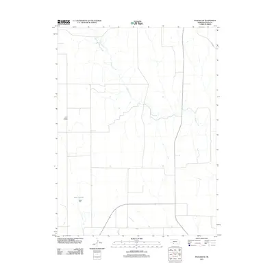
2011 Map of Palisade NE
USGS Topo · Published 2011About this map
Blackwood Creek meanders through this agricultural landscape in northeastern Hayes County, defining the drainage patterns of a quiet section of the Nebraska plains. This 2011 survey illustrates a sparse settlement pattern dominated by section-line roads and water management features. Smith Dam and the accompanying Smith Reservoir highlight the local necessity of water storage for the surrounding ranching or farming operations. For those researching family history or local landmarks, the Union Mission Cemetery stands as a significant point of interest, marking a historical site of community gathering and memory. The map also traces the route of Road 1465 as it cuts across the northern terrain, connecting this rural expanse to the broader regional network.
Find a feature on this map
5 named features on this map. Tap any name to fly to it.
Don’t see what you’re looking for? This feature index may not catch every label — zoom into the map to look around manually.
Map Details
Editions of this 2011 Palisade NE Map
This is the sole edition of this map. No revisions or reprints were ever made.
Other maps of this area

1954 · McCook
USGS Topo · 1:250,000

1957 · McCook
USGS Topo · 1:250,000

1958 · McCook
USGS Topo · 1:250,000

1973 · Palisade
USGS Topo · 1:24,000
1973 · Beverly
USGS Topo · 1:24,000

1973 · Palisade SW
USGS Topo · 1:24,000
1973 · Burger Canyon West
USGS Topo · 1:24,000

1974 · Hamlet
USGS Topo · 1:24,000

1974 · Hayes Center
USGS Topo · 1:24,000
1974 · Palisade NE
USGS Topo · 1:24,000