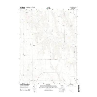
2014 Map of Palisade NE
USGS Topo · Published 2014About this map
Union Mission Cem sits in the southwestern corner of this Hayes County landscape, a key landmark for genealogists and local historians tracing early prairie settlement. The terrain is defined by the winding course of Blackwood Cr and the drainage patterns that have carved Government Canyon and Fish Canyon into the high plains. In the lower reaches of the map, the Smith Reservoir provides a localized water source within a predominantly agricultural grid. This 2014 survey documents the persistence of the section-line road system, with routes such as Road 736 and Avenue 363 providing the primary framework for movement through this rural Nebraska interior, where the topography transitions from flat plateaus to deeply etched draws.
Find a feature on this map
28 named features on this map. Tap any name to fly to it.
Don’t see what you’re looking for? This feature index may not catch every label — zoom into the map to look around manually.
Map Details
Editions of this 2014 Palisade NE Map
This is the sole edition of this map. No revisions or reprints were ever made.
Other maps of this area

1954 · McCook
USGS Topo · 1:250,000

1957 · McCook
USGS Topo · 1:250,000

1958 · McCook
USGS Topo · 1:250,000

1973 · Palisade
USGS Topo · 1:24,000
1973 · Beverly
USGS Topo · 1:24,000

1973 · Palisade SW
USGS Topo · 1:24,000
1973 · Burger Canyon West
USGS Topo · 1:24,000

1974 · Hamlet
USGS Topo · 1:24,000

1974 · Hayes Center
USGS Topo · 1:24,000
1974 · Palisade NE
USGS Topo · 1:24,000