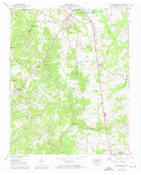
1950 Map of Palmer Shelter
USGS Topo · Published 1974About this map
The Tennessee Valley Divide snakes through this Carroll County landscape, marking the hydrologic boundary between the Tennessee and Mississippi River watersheds. In the mid-20th century, this rural district was defined by a network of small family-centered settlements like Leach, Palmer Shelter, and Clarksburg. The map reveals a high density of community landmarks essential for genealogical research, including the Liberty All Church Cem, Antioch Cem, and Sellers Cem. Educational history is preserved through the locations of the Pleasant Hill School and Scott Hill School, while the presence of a fish hatchery near Anark Ch indicates specialized land use in the bottomlands. Significant drainage modifications are evident along the Beaver Creek Drainage Canal, where engineered channels contrast with the natural winding paths of Rock Creek and Reedy Creek.
Find a feature on this map
56 named features on this map. Tap any name to fly to it.
Don’t see what you’re looking for? This feature index may not catch every label — zoom into the map to look around manually.
Map Details
Editions of this 1950 Palmer Shelter Map
3 editions found
Other maps of this area

1936 · Clarksburg
USGS Topo · 1:24,000

1936 · Yuma
USGS Topo · 1:24,000

1936 · Vale
USGS Topo · 1:24,000

1936 · Center Ridge
USGS Topo · 1:24,000

1936 · Buena Vista
USGS Topo · 1:24,000

1950 · Yuma
USGS Topo · 1:24,000

1950 · Palmer Shelter
USGS Topo · 1:24,000

1950 · Vale
USGS Topo · 1:24,000
1950 · Buena Vista
USGS Topo · 1:24,000

1950 · Clarksburg
USGS Topo · 1:24,000