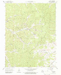
1958 Map of Palmer
USGS Topo · Published 1986About this map
Palmer and the surrounding terrain of the Fifth Principal Meridian define this mid-century Missouri landscape, where the industry of the Ozarks is evidenced by numerous mines and a Tailings Pond. This 1958 field-checked survey reveals a rural settlement pattern centered on family and community hubs like Marler Chapel, Lizzie Ch, and several family cemeteries including Sitton Cem and Horton Cem. The map is dominated by the Harmony Clark National Forest and the Belgrade area, characterized by a dense network of watercourses such as Hazel Creek, Trace Creek, and the Big River. The location of the Tiff Lookout Tower atop a high ridge provides a vantage point over the complex drainage systems of Little Lost Creek and Compton Branch, illustrating the area's timber and mineral resource management.
Find a feature on this map
44 named features on this map. Tap any name to fly to it.
Don’t see what you’re looking for? This feature index may not catch every label — zoom into the map to look around manually.
Map Details
Editions of this 1958 Palmer Map
4 editions found
Other maps of this area

1906 · Potosi
USGS Topo · 1:62,500

1924 · Edgehill
USGS Topo · 1:62,500

1926 · Edgehill
USGS Topo · 1:62,500

1943 · Berryman
USGS Topo · 1:62,500

1943 · Boss
USGS Topo · 1:62,500

1945 · Berryman
USGS Topo · 1:62,500

1946 · Boss
USGS Topo · 1:62,500

1949 · Rolla
USGS Topo · 1:250,000

1953 · Rolla
USGS Topo · 1:250,000

1954 · Rolla
USGS Topo · 1:250,000