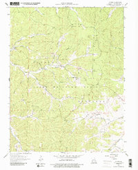
1958 Map of Palmer
USGS Topo · Published 1986About this map
The settlement of Palmer and the surrounding timberlands of the Mark Twain National Forest define this mid-century look at Washington County. The landscape is heavily marked by the region's mining heritage, with numerous unnamed Mines and a large Tailings Pond near Compton Branch. Local genealogy is well-represented through family-named landmarks and rural meeting places, including Marler Chapel, Hazel Creek Ch, and Lizzie Ch.
Find a feature on this map
38 named features on this map. Tap any name to fly to it.
Don’t see what you’re looking for? This feature index may not catch every label — zoom into the map to look around manually.
Map Details
Editions of this 1958 Palmer Map
4 editions found
Other maps of this area

1906 · Potosi
USGS Topo · 1:62,500

1924 · Edgehill
USGS Topo · 1:62,500

1926 · Edgehill
USGS Topo · 1:62,500

1943 · Berryman
USGS Topo · 1:62,500

1943 · Boss
USGS Topo · 1:62,500

1945 · Berryman
USGS Topo · 1:62,500

1946 · Boss
USGS Topo · 1:62,500

1949 · Rolla
USGS Topo · 1:250,000

1953 · Rolla
USGS Topo · 1:250,000

1954 · Rolla
USGS Topo · 1:250,000