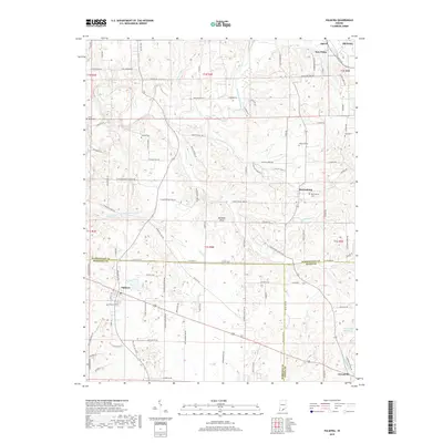
2019 Map of Palmyra
USGS Topo · Published 2019About this map
Palmyra and Martinsburg serve as central nodes in this landscape where Washington, Harrison, and Floyd Counties converge. The region is defined by the Mitchell Plain, a limestone plateau that influences the local drainage patterns of Bear Cr and Licking Cr. This 2019 survey documents a rural infrastructure where historical family names persist through the road network and numerous small burial grounds, such as David Voyles Cem and Rickard Cem.
Find a feature on this map
112 named features on this map. Tap any name to fly to it.
Don’t see what you’re looking for? This feature index may not catch every label — zoom into the map to look around manually.
Map Details
Editions of this 2019 Palmyra Map
This is the sole edition of this map. No revisions or reprints were ever made.
Other maps of this area

1939 · Georgetown
USGS Topo · 1:24,000

1941 · Borden
USGS Topo · 1:24,000

1946 · Depauw
USGS Topo · 1:24,000

1947 · Georgetown
USGS Topo · 1:24,000

1949 · Georgetown
USGS Topo · 1:24,000

1950 · Salem
USGS Topo · 1:24,000

1950 · Becks Mill
USGS Topo · 1:24,000

1950 · Palmyra
USGS Topo · 1:24,000
1952 · Georgetown
USGS Topo · 1:24,000

1953 · Fredericksburg
USGS Topo · 1:24,000