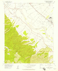
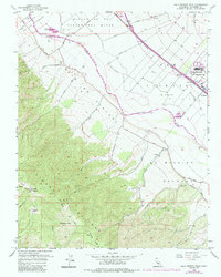
1956 Map of Palo Escrito Peak
USGS Topo · Published 1956About this map
The Salinas River valley in Monterey County is captured here at a time of agricultural and institutional expansion. The northeast portion of the map is dominated by the Soledad State Prison and the busy Southern Pacific railroad line, which served small trackside stops like Molus and Camphora. The landscape is a transition from the level river bottomlands to the steep, rising terrain of the Sierra de Salinas, where landmarks such as Palo Escrito Peak and Paloma Mtn define the western horizon.
Find a feature on this map
29 named features on this map. Tap any name to fly to it.
Don’t see what you’re looking for? This feature index may not catch every label — zoom into the map to look around manually.
Map Details
Editions of this 1956 Palo Escrito Peak Map
5 editions found
Other maps of this area

1910 · Gonzales
USGS Topo · 1:31,680

1910 · Salinas
USGS Topo · 1:31,680

1910 · Soledad
USGS Topo · 1:31,680

1912 · Salinas
USGS Topo · 1:62,500

1915 · Soledad
USGS Topo · 1:62,500

1920 · Jamesburg
USGS Topo · 1:48,000

1921 · Jamesburg
USGS Topo · 1:62,500

1921 · Gonzales
USGS Topo · 1:62,500

1939 · Jamesburg
USGS Topo · 1:62,500

1940 · Salinas
USGS Topo · 1:62,500