
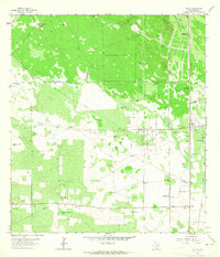
1968 Map of Palomas Ranch SE
USGS Topo · Published 1971About this map
Madrigueras Windmill and a network of water resources dot this South Texas landscape in Brooks County, captured during the late 1960s. The map reveals a ranching environment where life and industry centered on scattered water sources like Liescosa Well (Flowing) and Tres Puertas Well. The presence of Perez Cem suggests the deep-rooted family histories of the Palomas Ranch area, while the infrastructure of the era is represented by a Pipeline and several Oil Wells. Numerous named windmills, including San Cristobal Windmill, La Colcha Windmill, and Lindero Windmill, indicate the vital importance of groundwater for cattle in this scrubland. Small industrial sites like a Quarry and a Gravel Pit near Bult Hole show the local extraction of materials from the terrain.
Find a feature on this map
21 named features on this map. Tap any name to fly to it.
Don’t see what you’re looking for? This feature index may not catch every label — zoom into the map to look around manually.
Map Details
Editions of this 1968 Palomas Ranch SE Map
This is the sole edition of this map. No revisions or reprints were ever made.
Other maps of this area

1921 · Falfurrias
USGS Topo · 1:125,000

1939 · Encantada
USGS Topo · 1:62,500

1949 · Mc Allen
USGS Topo · 1:250,000

1954 · McAllen
USGS Topo · 1:250,000

1956 · Laredo
USGS Topo · 1:250,000

1957 · Mc Allen
USGS Topo · 1:250,000

1962 · McAllen
USGS Topo · 1:250,000

1963 · Cage Ranch
USGS Topo · 1:24,000
1963 · Encino
USGS Topo · 1:24,000

1963 · Falfurrias
USGS Topo · 1:24,000