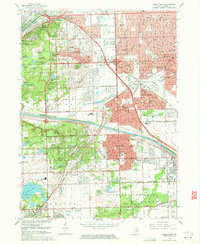
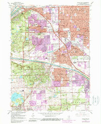
1963 Map of Palos Park
USGS Topo · Published 1965About this map
The Calumet Sag Channel and the Chicago Sanitary and Ship Canal dominate this 1960s landscape, illustrating the massive industrial and hydraulic engineering that reshaped the region's natural drainage. While the eastern half of the map shows the dense suburban expansion of Oak Lawn, Worth, and Chicago Ridge, the western portion is preserved as a vast network of wooded terrain. This area, largely defined by the Palos Forest Preserve, retains its glacial character through features like Swallow Cliffs and a series of uniquely named wetlands, including Boomerang Slough and Laughing Squaw Sloughs.
Find a feature on this map
110 named features on this map. Tap any name to fly to it.
Don’t see what you’re looking for? This feature index may not catch every label — zoom into the map to look around manually.
Map Details
Editions of this 1963 Palos Park Map
5 editions found
Other maps of this area

1889 · Chicago
USGS Topo · 1:62,500

1890 · Des Plaines
USGS Topo · 1:62,500

1891 · Chicago
USGS Topo · 1:62,500

1891 · Riverside
USGS Topo · 1:62,500

1892 · Calumet
USGS Topo · 1:62,500

1893 · Calumet
USGS Topo · 1:62,500

1893 · Riverside
USGS Topo · 1:62,500

1894 · Des Plaines
USGS Topo · 1:62,500

1900 · Chicago
USGS Topo · 1:62,500

1900 · Des Plaines
USGS Topo · 1:62,500
Featured Places
- Oak Lawn, Worth Township
- Orland Park, Orland Township
- Burbank, Stickney Township
- Oak Forest, Bremen Township
- Alsip, Worth Township