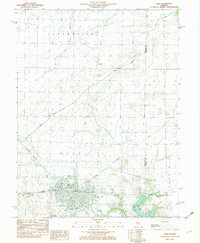
1982 Map of Pana
USGS Topo · Published 1982About this map
The city of Pana serves as the focal point of this Central Illinois landscape, where the confluence of major rail lines and agricultural drainage systems shaped the local economy. At the time of this survey, the Baltimore and Ohio and Conrail railroads intersect within the city limits, supporting a developed industrial and civic center. To the north, the small settlement of Dunkel is surrounded by the vast grid of the Assumption and Pana townships, dominated by the George Branch and several man-made drainage systems like the Main Drainage Ditch. On the southern edge of town, the landscape transitions to recreation and community heritage, marked by the Tri County Fairground, the Country Club Golf Course, and significant burial grounds including Calvary Cem and Mound Cem. The presence of Lake Pana and Paragon Lake provides a stark contrast to the surrounding rural plains of Rural Tower Hill.
Find a feature on this map
26 named features on this map. Tap any name to fly to it.
Don’t see what you’re looking for? This feature index may not catch every label — zoom into the map to look around manually.
Map Details
Editions of this 1982 Pana Map
This is the sole edition of this map. No revisions or reprints were ever made.
Other maps of this area

1942 · Shelbyville
USGS Topo · 1:62,500

1946 · Shelbyville
USGS Topo · 1:62,500

1947 · Pana
USGS Topo · 1:62,500

1949 · Dalton City
USGS Topo · 1:62,500

1949 · Pana
USGS Topo · 1:62,500

1952 · Assumption
USGS Topo · 1:62,500

1958 · Decatur
USGS Topo · 1:250,000

1961 · Decatur
USGS Topo · 1:250,000

1974 · Willeys
USGS Topo · 1:24,000
1981 · Lakewood
USGS Topo · 1:24,000