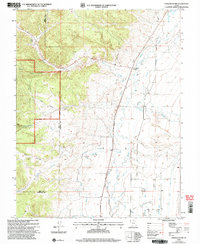
2002 Map of Panguitch NW
USGS Topo · Published 2005About this map
The Dixie National Forest dominates the western landscape of this Garfield County region, where the high terrain drops sharply toward the agricultural corridor of the Sevier River. The irrigation infrastructure of the valley is clearly defined by the Panguitch Canal and its associated siphons and ditches, illustrating the vital water management required for ranching and farming in this arid environment. Near the center of the valley, a small Cem stands as a quiet marker of early settlement history, while Bear Valley Junction serves as the primary hub for local transit.
Find a feature on this map
20 named features on this map. Tap any name to fly to it.
Don’t see what you’re looking for? This feature index may not catch every label — zoom into the map to look around manually.
Map Details
Editions of this 2002 Panguitch NW Map
This is the sole edition of this map. No revisions or reprints were ever made.
Other maps of this area

1885 · Beaver
USGS Topo · 1:250,000

1886 · Kanab
USGS Topo · 1:250,000

1953 · Richfield
USGS Topo · 1:250,000

1953 · Cedar City
USGS Topo · 1:250,000

1958 · Richfield
USGS Topo · 1:250,000

1958 · Cedar City
USGS Topo · 1:250,000

1962 · Cedar City
USGS Topo · 1:250,000

1966 · Bull Rush Peak
USGS Topo · 1:24,000

1966 · Fremont Pass
USGS Topo · 1:24,000

1966 · Panguitch NW
USGS Topo · 1:24,000