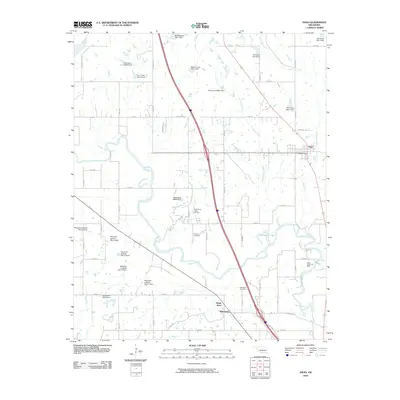
2010 Map of Paoli
USGS Topo · Published 2010About this map
The Washita River meanders across this landscape, forming prominent loops and the distinct Horseshoe Lake oxbow north of the White Bead and Whitebead communities. This era in Garvin County is characterized by a mix of agricultural valley land and active petroleum extraction, evidenced by the West Pauls Valley Oil Field and the Pauls Valley Oil Field. The town of Paoli sits in the northeast corner of the map, serving as a local hub near the intersection of US Highway 77 and Interstate 35. Numerous watershed management projects are visible through a series of dams, including the Maysville Laterals and Owl Creek systems. Genealogists will find the Florence Cemetery and Whitebead Cemetery as significant local landmarks of the area's long-established settlement history.
Find a feature on this map
62 named features on this map. Tap any name to fly to it.
Don’t see what you’re looking for? This feature index may not catch every label — zoom into the map to look around manually.
Map Details
Editions of this 2010 Paoli Map
This is the sole edition of this map. No revisions or reprints were ever made.
Other maps of this area

1898 · Pauls Valley
USGS Topo · 1:125,000

1902 · Pauls Valley
USGS Topo · 1:125,000

1957 · Ardmore
USGS Topo · 1:250,000

1963 · Ardmore
USGS Topo · 1:250,000
1965 · Rosedale
USGS Topo · 1:24,000

1965 · Byars SW
USGS Topo · 1:24,000
1965 · Wayne
USGS Topo · 1:24,000

1965 · Pauls Valley
USGS Topo · 1:24,000

1965 · Maysville
USGS Topo · 1:24,000

1965 · Paoli
USGS Topo · 1:24,000