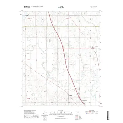
2018 Map of Paoli
USGS Topo · Published 2018About this map
The Washita River meanders through the heart of this Garvin County landscape, shaping a terrain defined by fertile floodplains and low-lying oxbows like Horseshoe Lake. The settlement pattern centers on the corridor between Paoli and the northern reaches of Pauls Valley, connected by a grid of rural routes such as State Hwy 145 and Randolph Rd. These roads link isolated farmsteads with local landmarks that anchor the community's history, including the White Bead area and the adjacent Whitebead Cem.
Find a feature on this map
64 named features on this map. Tap any name to fly to it.
Don’t see what you’re looking for? This feature index may not catch every label — zoom into the map to look around manually.
Map Details
Editions of this 2018 Paoli Map
This is the sole edition of this map. No revisions or reprints were ever made.
Other maps of this area

1898 · Pauls Valley
USGS Topo · 1:125,000

1902 · Pauls Valley
USGS Topo · 1:125,000

1957 · Ardmore
USGS Topo · 1:250,000

1963 · Ardmore
USGS Topo · 1:250,000
1965 · Rosedale
USGS Topo · 1:24,000

1965 · Byars SW
USGS Topo · 1:24,000
1965 · Wayne
USGS Topo · 1:24,000

1965 · Pauls Valley
USGS Topo · 1:24,000

1965 · Maysville
USGS Topo · 1:24,000

1965 · Paoli
USGS Topo · 1:24,000