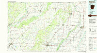
1984 Map of Paragould
USGS Topo · Published 1984About this map
Crowleys Ridge rises above the alluvial plains of the Mississippi Embayment, serving as the geological backbone for this 1980s landscape across Northeast Arkansas and Southeast Missouri. The elevated terrain provides a natural corridor for settlements like Paragould, Piggott, and Rector, contrasting sharply with the densely ditched and drained lowlands to the east. Extensive water management is evident through systems such as Ditch No 1, Ditch No 2, and the Main Ditch, which transformed the former wetlands of the St. Francis Basin into productive acreage. Transportation networks are anchored by the St Louis Southwestern RR and Missouri Pacific RR, connecting agricultural hubs like Corning and Walnut Ridge. The map also captures significant conservation and recreation areas, including the Little Island Area Wildlife Management Area and Crowleys Ridge State Park, preserving fragments of the region's original environment amidst its engineered drainage projects.
Find a feature on this map
246 named features on this map. Tap any name to fly to it.
Don’t see what you’re looking for? This feature index may not catch every label — zoom into the map to look around manually.
Map Details
Editions of this 1984 Paragould Map
2 editions found
Other maps of this area

1932 · Walnut Ridge
USGS Topo · 1:62,500

1934 · Kennett
USGS Topo · 1:62,500

1934 · Powhatan
USGS Topo · 1:62,500

1935 · Powhatan
USGS Topo · 1:62,500

1935 · Acorn
USGS Topo · 1:62,500

1935 · Sedgwick
USGS Topo · 1:62,500

1935 · Alicia
USGS Topo · 1:62,500

1935 · Rector
USGS Topo · 1:62,500

1935 · Knobel
USGS Topo · 1:62,500

1935 · Reyno
USGS Topo · 1:62,500