
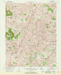
1954 Map of Park
USGS Topo · Published 1955About this map
The Dixie Highway and Jackson Highway converge in this mid-century landscape, meeting at the historic crossroads of Bear Wallow. This area of south-central Kentucky is characterized by a dense concentration of sinkholes and karst topography, punctuated by prominent high points such as Wootens Knob and Allison Knob. Small rural communities like Uno, LeGrande, and Seymour anchor the agricultural terrain, each marked by local landmarks like Bear Wallow Ch and the Oak Ridge Sch.
Find a feature on this map
30 named features on this map. Tap any name to fly to it.
Don’t see what you’re looking for? This feature index may not catch every label — zoom into the map to look around manually.
Map Details
Editions of this 1954 Park Map
2 editions found
Other maps of this area

1934 · Munfordville
USGS Topo · 1:48,000

1935 · Horse Cave
USGS Topo · 1:48,000

1937 · Munfordville
USGS Topo · 1:62,500

1938 · Horse Cave
USGS Topo · 1:62,500

1953 · Sulphur Well
USGS Topo · 1:24,000

1953 · Hudgins
USGS Topo · 1:24,000

1953 · Munfordville
USGS Topo · 1:24,000

1953 · Center
USGS Topo · 1:24,000
1953 · Canmer
USGS Topo · 1:24,000

1954 · Horse Cave
USGS Topo · 1:24,000