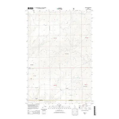
2014 Map of Park
USGS Topo · Published 2014About this map
Park and Linden anchor this rural landscape where the headwaters of numerous creeks carve through the ridges of Nez Perce and Latah Counties. The area is defined by its topographic extremes, from the high points of Gold Hill and the long spine of Tamarack Ridge down to the narrow drainages of Boulder Cr and Three Bear Cr. Settlement patterns follow the high ground and available road networks like Park Rd and Cedar Ridge Rd, with small communities like Crescent and Aspendale situated among the timbered slopes. This 2014 survey captures the precise boundaries between Latah, Nez Perce, and Clearwater Counties, illustrating how these administrative lines often bisect natural features like Kauder Cr and Longfellow Gulch. The map provides a detailed view of the regional geography just before significant modern developments, showing the established rural road system and the names of small ridges such as Norwegian Ridge.
Find a feature on this map
30 named features on this map. Tap any name to fly to it.
Don’t see what you’re looking for? This feature index may not catch every label — zoom into the map to look around manually.
Map Details
Editions of this 2014 Park Map
This is the sole edition of this map. No revisions or reprints were ever made.
Other maps of this area

1955 · Pullman
USGS Topo · 1:250,000

1958 · Pullman
USGS Topo · 1:250,000

1961 · Deary
USGS Topo · 1:62,500

1961 · Kendrick
USGS Topo · 1:62,500

1961 · Ahsahka
USGS Topo · 1:62,500

1961 · Bovill
USGS Topo · 1:62,500

1981 · Potlatch
USGS Topo · 1:100,000
1990 · Ahsahka
USGS Topo · 1:24,000
1990 · Lenore
USGS Topo · 1:24,000
1990 · Mc Gary Butte
USGS Topo · 1:24,000