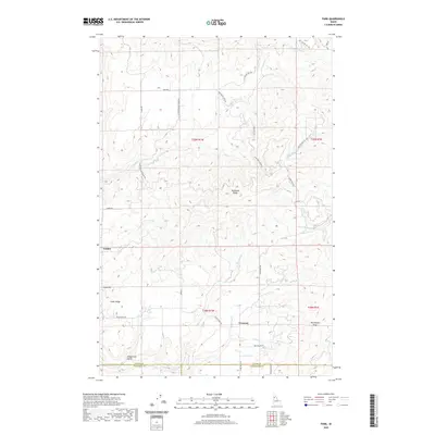
2020 Map of Park
USGS Topo · Published 2020About this map
Park and Linden sit amidst a complex network of ridges and drainages in this upland region of northern Idaho. The landscape is defined by its deep watercourses, including Three Bear Cr and its many tributaries like Bedbug Cr, which carve through the high ground of Tamarack Ridge and Norwegian Ridge. The boundary between Latah, Nez Perce, and Clearwater counties intersects here, illustrating how these early administrative lines were drawn across the high divides and creek bottoms of the Clearwater River watershed. Forest development roads, such as Nat For Dev Rd 1963, crisscross the area, tracing the routes established for timber access and land management. Further south, the settlements of Crescent and landmarks like Gold Hill provide focal points for historical research into the rural development of this territory, where isolated homesteads were linked by winding paths like Cedar Ridge Rd and Three Bear Rd.
Find a feature on this map
34 named features on this map. Tap any name to fly to it.
Don’t see what you’re looking for? This feature index may not catch every label — zoom into the map to look around manually.
Map Details
Editions of this 2020 Park Map
This is the sole edition of this map. No revisions or reprints were ever made.
Other maps of this area

1955 · Pullman
USGS Topo · 1:250,000

1958 · Pullman
USGS Topo · 1:250,000

1961 · Deary
USGS Topo · 1:62,500

1961 · Kendrick
USGS Topo · 1:62,500

1961 · Ahsahka
USGS Topo · 1:62,500

1961 · Bovill
USGS Topo · 1:62,500

1981 · Potlatch
USGS Topo · 1:100,000
1990 · Ahsahka
USGS Topo · 1:24,000
1990 · Lenore
USGS Topo · 1:24,000
1990 · Mc Gary Butte
USGS Topo · 1:24,000