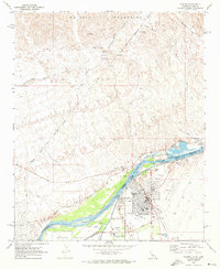
1970 Map of Parker
USGS Topo · Published 1973About this map
Parker and Earp flank the Colorado River in this 1970 snapshot, marking a critical crossing point on the border between California and Arizona. The town of Parker serves as a hub for the Colorado River Indian Reservation, with the Colorado River Indian Agency Headquarters and the Tribes Administration Center established as central landmarks. To the west, the Wyatt Earp House stands as a testament to the region’s frontier legacy. The landscape is defined by the massive Colorado River Aqueduct and the Headgate Rock Dam, which creates Moovalya Lake. Transportation and industry are well-represented by the Atchison Topeka and Santa Fe railroad, the Parker Municipal Airport, and several extraction sites like the Blue Cloud Mine and various borrow pits.
Find a feature on this map
41 named features on this map. Tap any name to fly to it.
Don’t see what you’re looking for? This feature index may not catch every label — zoom into the map to look around manually.
Map Details
Editions of this 1970 Parker Map
3 editions found
Other maps of this area

1911 · Parker
USGS Topo · 1:125,000

1943 · Giers Basin
USGS Topo · 1:62,500

1943 · Whipple Mts.
USGS Topo · 1:62,500

1943 · Parker
USGS Topo · 1:62,500

1949 · Parker
USGS Topo · 1:62,500

1950 · Parker Dam Area
USGS Topo · 1:62,500

1950 · Parker
USGS Topo · 1:62,500

1950 · Whipple Mts
USGS Topo · 1:62,500

1952 · Whipple Mts
USGS Topo · 1:62,500

1954 · Needles
USGS Topo · 1:250,000