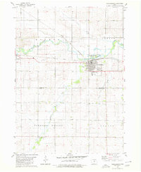
1980 Map of Parkersburg
USGS Topo · Published 1980About this map
Parkersburg serves as the primary hub of this 1980 survey, where the dual corridors of the Chicago and North Western and Illinois Central Gulf railroads intersect. This transportation nexus shaped the growth of the surrounding prairie, connecting local agricultural centers like Aplington and the smaller settlement of Eleanor to wider markets. The landscape is defined by the winding course of Beaver Creek, which flows through the Beaver Meadows County Park just north of the Parkersburg town site.
Find a feature on this map
27 named features on this map. Tap any name to fly to it.
Don’t see what you’re looking for? This feature index may not catch every label — zoom into the map to look around manually.
Map Details
Editions of this 1980 Parkersburg Map
This is the sole edition of this map. No revisions or reprints were ever made.
Other maps of this area

1954 · Waterloo
USGS Topo · 1:250,000

1955 · Waterloo
USGS Topo · 1:250,000

1971 · Dike
USGS Topo · 1:24,000

1971 · Coster
USGS Topo · 1:24,000

1971 · Stout
USGS Topo · 1:24,000

1979 · Holland
USGS Topo · 1:24,000

1979 · Dumont South
USGS Topo · 1:24,000

1979 · Butler Center
USGS Topo · 1:24,000

1980 · Aplington
USGS Topo · 1:24,000

1980 · Wellsburg
USGS Topo · 1:24,000