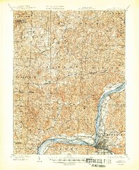
1904 Map of Parkersburg
USGS Topo · Published 1948About this map
Blennerhassett Island sits prominently in the Ohio River at the turn of the century, serving as a focal point for this borderland geography between West Virginia and Ohio. The industrial and transit hub of Parkersburg is captured just as its urban footprint begins to expand into surrounding neighborhoods like Beechwood, Riverside, and Lauckport. The river dominates the economy, supported by the extensive Baltimore and Ohio R.R. lines that follow the shoreline and connect these river towns to the interior.
Find a feature on this map
71 named features on this map. Tap any name to fly to it.
Don’t see what you’re looking for? This feature index may not catch every label — zoom into the map to look around manually.
Map Details
Editions of this 1904 Parkersburg Map
5 editions found
Other maps of this area

1902 · Parkersburg
USGS Topo · 1:62,500

1903 · Macksburg
USGS Topo · 1:62,500

1904 · Parkersburg
USGS Topo · 1:62,500

1904 · Marietta
USGS Topo · 1:62,500

1904 · Chesterhill
USGS Topo · 1:62,500

1905 · Macksburg
USGS Topo · 1:62,500

1906 · Elizabeth
USGS Topo · 1:62,500

1906 · Belleville
USGS Topo · 1:62,500

1906 · Chesterhill
USGS Topo · 1:62,500

1907 · Keno
USGS Topo · 1:62,500