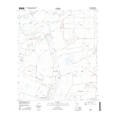
2015 Map of Parks
USGS Topo · Published 2015About this map
Bayou Teche defines the central axis of this Saint Martin Parish landscape, winding past the village of Parks and the settlement of Saint John. The map reveals a transition from the structured street grid of northern St. Martinville to the expansive rural tracts and plantation lands along the water. To the west, the low-lying Cypress Island is drained by a network of waterways including Cypress Island Coulee, while the east is marked by the meandering paths of Bayou Martin and Catahoula Coulee. Significant landholdings like Banker Plantation and smaller hubs such as Levert and Isle Labbe illustrate the persistent agricultural and residential patterns of the Teche valley. Specialized facilities like Ace Flying Airport and Castille Field serve the open country between the bayous and the parish boundaries.
Find a feature on this map
115 named features on this map. Tap any name to fly to it.
Don’t see what you’re looking for? This feature index may not catch every label — zoom into the map to look around manually.
Map Details
Editions of this 2015 Parks Map
This is the sole edition of this map. No revisions or reprints were ever made.
Other maps of this area

1935 · Osca Bayou
USGS Topo · 1:62,500

1939 · St. Martinsville
USGS Topo · 1:62,500

1940 · Arnaudville
USGS Topo · 1:62,500

1941 · Loreauville
USGS Topo · 1:62,500

1954 · Loreauville
USGS Topo · 1:62,500

1954 · Baton Rouge
USGS Topo · 1:250,000

1955 · Osca Bayou
USGS Topo · 1:62,500

1956 · Baton Rouge
USGS Topo · 1:250,000

1957 · St. Martinville
USGS Topo · 1:62,500
1959 · Osca Bayou
USGS Topo · 1:62,500