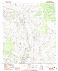
1983 Map of Parks
USGS Topo · Published 1983About this map
Bayou Teche defines the cultural and economic spine of this Acadiana landscape, winding past the historic settlements of Parks and St Martinville in the early 1980s. The map illustrates a distinctive transition from the structured plantation-era land divisions along the bayou to the expansive wetlands of the east. Local industry is clearly visible through numerous Oil Wells and a prominent Crawfish Farm near Isle Labbe, reflecting the region's reliance on both mineral extraction and traditional aquaculture.
Find a feature on this map
21 named features on this map. Tap any name to fly to it.
Don’t see what you’re looking for? This feature index may not catch every label — zoom into the map to look around manually.
Map Details
Editions of this 1983 Parks Map
This is the sole edition of this map. No revisions or reprints were ever made.
Other maps of this area

1935 · Osca Bayou
USGS Topo · 1:62,500

1939 · St. Martinsville
USGS Topo · 1:62,500

1940 · Arnaudville
USGS Topo · 1:62,500

1941 · Loreauville
USGS Topo · 1:62,500

1954 · Loreauville
USGS Topo · 1:62,500

1954 · Baton Rouge
USGS Topo · 1:250,000

1955 · Osca Bayou
USGS Topo · 1:62,500

1956 · Baton Rouge
USGS Topo · 1:250,000

1957 · St. Martinville
USGS Topo · 1:62,500
1959 · Osca Bayou
USGS Topo · 1:62,500