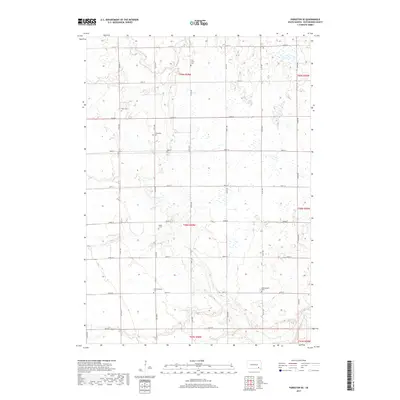
2017 Map of Parkston SE
USGS Topo · Published 2017About this map
Agricultural patterns and historical burial grounds define this Hutchinson County landscape in the early 21st century. The map reveals a high concentration of cemeteries including Drei Creek Cem, Kulm Cem, and Friedenfeld Cem, which likely point to early settlement hubs and specific immigrant congregations in this part of South Dakota. These sites are interspersed among a methodical grid of gravel roads such as 277th St and 417th Ave. Drainage for the township is provided by several meandering waterways, most notably Lonetree Cr and the split branches of N Br Drei Cr and S Br Drei Cr. Further south, the map identifies the Bethel 2 Cem and two separate locations for Hoffnungstahl Cem, providing critical geographic markers for genealogists tracing families in the Wittenberg Township area. The terrain is marked by numerous small depressions and ponds typical of the regional prairie pothole topography.
Find a feature on this map
31 named features on this map. Tap any name to fly to it.
Don’t see what you’re looking for? This feature index may not catch every label — zoom into the map to look around manually.
Map Details
Editions of this 2017 Parkston SE Map
This is the sole edition of this map. No revisions or reprints were ever made.
Other maps of this area

1898 · Olivet
USGS Topo · 1:125,000

1955 · Sioux Falls
USGS Topo · 1:250,000

1957 · Tschetter Colony
USGS Topo · 1:24,000

1957 · Milltown
USGS Topo · 1:24,000

1957 · Clayton
USGS Topo · 1:24,000

1957 · Scotland
USGS Topo · 1:24,000

1958 · Sioux Falls
USGS Topo · 1:250,000
1978 · Kaylor
USGS Topo · 1:24,000
1978 · Tripp
USGS Topo · 1:24,000
1980 · Parkston SE
USGS Topo · 1:24,000