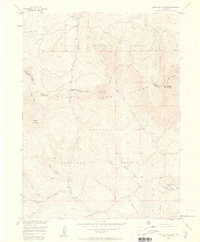
1956 Map of Parkview Mountain
USGS Topo · Published 1958About this map
The high alpine intersection of the Continental Divide and the Rabbit Ears Range defines this high-altitude landscape on the border of Grand and Jackson counties. Published in the late 1950s from earlier aerial surveys, the map showcases a terrain dominated by the timberlines of the Routt National Forest and Arapaho National Forest. Human presence is sparse, marked primarily by the Trails End Ranch in the southeast and a network of remote paths like the Arapaho Creek Trail and various Pack Trail segments. The hydrological pattern is complex, with the headwaters of Troublesome Creek and Willow Creek carving deep drainages away from the central peaks of Parkview Mountain and Haystack Mountain. These water sources, including Buffalo Creek and McBride Creek, underscore the importance of the watershed in this era of forest management.
Find a feature on this map
30 named features on this map. Tap any name to fly to it.
Don’t see what you’re looking for? This feature index may not catch every label — zoom into the map to look around manually.
Map Details
Editions of this 1956 Parkview Mountain Map
5 editions found
Other maps of this area

1954 · Craig
USGS Topo · 1:250,000

1956 · Radial Mountain
USGS Topo · 1:24,000

1956 · Jack Creek Ranch
USGS Topo · 1:24,000

1956 · Kremmling
USGS Topo · 1:62,500

1956 · Parkview Mountain
USGS Topo · 1:24,000

1956 · Buffalo Peak
USGS Topo · 1:24,000

1956 · Hyannis Peak
USGS Topo · 1:24,000

1956 · Rand
USGS Topo · 1:24,000

1956 · Hyannis Peak
USGS Topo · 1:62,500

1956 · Rand
USGS Topo · 1:62,500