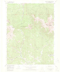
1956 Map of Parkview Mountain
USGS Topo · Published 1973About this map
The Continental Divide winds through this high-altitude landscape in the mid-1950s, defining the crest of the Rabbit Ears Range at the intersection of Grand, Routt, and Jackson counties. This survey serves as a detailed record of the headwaters for several significant drainage systems, including Willow Creek and Troublesome Creek, which flow through the Routt National Forest and Arapaho National Forest. High peaks like Parkview Mountain and Haystack Mountain dominate the skyline, while the human footprint is limited to remote outposts such as Trails End Ranch. Movement across this difficult terrain is marked by established routes like the Arapaho Creek Trail and Troublesome Pass, alongside numerous unnamed pack trails. The presence of features such as Beaver Ponds and various seasonal gulches like Paradise Gulch illustrates a primitive wilderness before modern development altered the high-country hydrology.
Find a feature on this map
33 named features on this map. Tap any name to fly to it.
Don’t see what you’re looking for? This feature index may not catch every label — zoom into the map to look around manually.
Map Details
Editions of this 1956 Parkview Mountain Map
5 editions found
Other maps of this area

1954 · Craig
USGS Topo · 1:250,000

1956 · Radial Mountain
USGS Topo · 1:24,000

1956 · Jack Creek Ranch
USGS Topo · 1:24,000

1956 · Kremmling
USGS Topo · 1:62,500

1956 · Parkview Mountain
USGS Topo · 1:24,000

1956 · Buffalo Peak
USGS Topo · 1:24,000

1956 · Hyannis Peak
USGS Topo · 1:24,000

1956 · Rand
USGS Topo · 1:24,000

1956 · Hyannis Peak
USGS Topo · 1:62,500

1956 · Rand
USGS Topo · 1:62,500