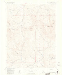
1956 Map of Parkview Mountain
USGS Topo · Published 1963About this map
The Continental Divide snake-like path through this high-altitude landscape defines the drainage patterns of Grand and Jackson Counties. On this mid-century survey, the high peaks of Parkview Mountain and Haystack Mountain tower over a complex network of headwaters including Troublesome Creek and Willow Creek. Human presence is sparse, marked primarily by the isolated Trails End Ranch and the historical Arapaho Creek Trail. The boundary between the Arapaho National Forest and Routt National Forest follows the jagged ridgelines, where names like Poison Ridge and Sheep Mountain suggest the rugged ranching and wildlife history of the region. This 1956 field check captures a landscape of natural springs and beaver ponds, documenting the backcountry before modern development altered these remote drainages.
Find a feature on this map
29 named features on this map. Tap any name to fly to it.
Don’t see what you’re looking for? This feature index may not catch every label — zoom into the map to look around manually.
Map Details
Editions of this 1956 Parkview Mountain Map
5 editions found
Other maps of this area

1954 · Craig
USGS Topo · 1:250,000

1956 · Radial Mountain
USGS Topo · 1:24,000

1956 · Jack Creek Ranch
USGS Topo · 1:24,000

1956 · Kremmling
USGS Topo · 1:62,500

1956 · Parkview Mountain
USGS Topo · 1:24,000

1956 · Buffalo Peak
USGS Topo · 1:24,000

1956 · Hyannis Peak
USGS Topo · 1:24,000

1956 · Rand
USGS Topo · 1:24,000

1956 · Hyannis Peak
USGS Topo · 1:62,500

1956 · Rand
USGS Topo · 1:62,500